In this section, we deal with Earth Tremors, Earthquakes, Volcanoes & Supervolcanoes.
Earth tremors are short-lived and soon passing, as well as being generally less severe than a full earthquake. Both earth tremors and earthquakes occur along seismic faults. These are weaknesses in the earth’s crust and these can stretch from only a few miles or so, up to many hundreds of miles (such as the San Andreas fault line in California). Some of these are close to the surface, but many are also much deeper.
In Cornwall, we do not have many earth tremors, but we do experience them occasionally. One of the main (fairly active) faults runs from the Falmouth Bay area, right up through Penryn (Estuary & Town) to around the Kernick/Asda’s roundabout area and thence up to the Mabe (Carnsew quarry) area. It then splits into two separate ‘minor’ faults. Firstly, it goes down to the Constantine & Port Navas area, and then, (secondly) it goes through Stithians and thence to the Rinsey/Praa Sands area and then directly into Penzance coastal parts. There also seems to be a minor fault which is close to the north Cornish coastal area (somewhere between Padstow & Wadebridge). Again, interestingly enough this may well be associated with an ‘estuary’! In Cornwall, recorded magnitudes are seemingly, usually between 1.0 and 3.4.
Other earth tremors and earthquakes can (and do!) occur in the U.K, but these are generally more concentrated in North Wales & Scotland, as well as in the North Sea and the North Sea coastal districts, more especially around Essex & Kent. (again an estuary!). More rarely, they can also occur in more inland and central parts, such as around the Birmingham and Bedfordshire areas. The strongest earthquake so far recorded in the U.K. was the Dogger Bank earthquake in the North Sea. It was a Magnitude 6.1 earthquake which occurred on the 7th June, 1931 and this resulted in extensive damage down the east coast, coastal landslides and even a small non-damaging tsunami. The magnitude has to be above a magnitude 2.5 to feel it at the surface.
Earth is composed of a number of massive tectonic plates which are constantly slowly moving, – these both compressing up against each other and also riding down beneath another plate (this is called subduction action). Another sort is a ‘strike/slip’ zone where the plates slip from side to side. Along the plate edges, there are usually volcanoes as well. Some of these are dormant, some are active & some are highly active. When a plate edge (or fault) breaks, (or springs back in the case of a subduction event), an earthquake occurs. Earthquake stress waves travel outwards at 8Km per second. If this should happen (shallowly) under the sea, then a tsunami can occur. A classic example of this occurred in the Philippines on 24th December, 2004. Another major earthquake and tsunami affected the eastern coast of Japan on March 11th, 2011 and this resulted in in excess of 15,000 deaths. The aforementioned San Andreas fault is one of the world’s most dangerous ones. The San Francisco area of California is now well overdue a massive earthquake (the last major one was on 18th April, 1906!) and the longer the delay, the bigger the eventual earthquake will be! There is also growing evidence to suggest that, especially before the largest (compression) earthquakes, then there may be a release of so-called ‘earth lights’. These can sometimes appear up to a week or so before a major earthquake. It has been suggested that this may be due to an almost a ‘piezo-electric’ affect caused by pressure building up gradually and suddenly being released by quartz rock formations. There is also some evidence to suggest (this is still being investigated) that especially some of the larger earthquakes (and possibly also some volcanoes) may be triggered by the extra gravitational effects caused by a ‘full’ moon (and to a lesser extent also, a ‘new’ moon). The molten (outer) core of the Earth is around 1800 miles in depth with temperatures of around 4000 degrees. There is also growing evidence that the sun may play a part in the occurrence of (especially larger) earthquakes, this being caused by large C.M.E.’s (Coronal Mass Ejections) which may well affect the Earth’s Geomagnetic Field. Research is currently ongoing into this. There is a worldwide network of magnetic observation stations which continuously monitor the Earth’s magnetic field. This is the International Real-time Magnetic Observatory Network and this can be found at: intermagnet.org
With this in mind, some combined Earth, Seismic & Solar data can be found at: www.earthevolution.com/energy-analytics This begins with Earth Analytics (Schumann Resonances 0-40Hz (Ez) Spectrogram UTC + 7), followed by Global Seismic Activity Level (last 90 days), then comes Real time Radiation Belts (past 7 days) (Earth’s magnetic field lines), Auroral Intensity Prediction and finally, Solar Analytics (Real Time Earth-Facing views of the Sun (last 48-72hrs) (these are large-scale coloured discs of the sun – these are excellent and are very effective to look at!)
Earthquake magnitudes increase logarithmically (e.g. they are 10 times higher in strength than the previous one (i.e. from Mag. 1 to Mag. 9 = 10 times higher!). Each whole Magnitude produces 32 times more energy than the previous one! A Megaquake is considered to be an earthquake of Magnitude 8.0 or above.
A very large and destructive earthquake occurred in Lisbon, Portugal in 1755 and this was known as the Great Lisbon Earthquake.
The largest known earthquake in the World occurred on 22nd May, 1960 at Valdivia on the S.W. coast of Chile, South America and this measured a massive 9.5 on the Richter Scale. This was immediately followed by a very destructive tsunami.
Volcanoes & Calderas: Some of the most destructive volcanoes result in ‘calderas’. This is when an underwater volcano erupts, sending several square kilometres of crustal rock up into the atmosphere. Sea water then floods in – hence causing a cataclysmic explosion. These can also cause major earthquakes and tsunamis (as well as atmospheric blast waves being recorded over the whole of the world!). One of the biggest of these events occurred on 10th April, 1815 in an eruption at Tambora in Indonesia. More than 50 Cubic kilometres of magma collapsed and thence formed a 6 Kilometre wide and 1,250 metre deep caldera in the wake of this massive eruption. It was this eruption that produced the famous ‘year with out a summer. In the east of the U.S. there was snow in July & August and the mean ‘summer’ temperature dipped by 5 degrees. Although not a caldera as such, Mount Vesuvius near Naples in Italy created a huge eruption which occurred in A.D. 79. This was the famous disaster that destroyed Pompeii and killed thousands of people. This, still active volcano could erupt at any time and it is being closely monitored. The most dangerous gas produced by major eruptions is SO2 (sulphur dioxide) and this gets blasted into the upper atmosphere and mixes with water vapour, so producing droplets of sulphuric acid. Because of the reflective nature of these frozen platelets, (and also volcanic dust) incoming solar radiation is directed back into space, thence resulting in rapid cooling at the surface. The biggest known volcanic explosion in the Northern Hemisphere occurred in 1600 B.C. and was on the island of Thera of of the coast of Greece. This caused the destruction of the island and resulted in a deep caldera forming. There was also a massive Tsunami which resulted in terrible destruction and loss of life all around the Aegean area. Indonesia has a number of active volcanoes with one of the most dangerous being Mount Sinabung on the island of Sumatra. This one is capable of throwing ash up to 7Km high and this one can also produce pyroclastic flows. Another (presently sleeping!) volcano is a natural lake called Lake Toba. This is a caldera supervolcano and is located in the north of Sumatra. Another potentially disastrous stratovolcano is Mount Pinatubo in the Phillipines. The last major eruption of this one was on 15th June, 1991 and was the second-largest eruption of the 20th Century. This eruption produced a global temperature reduction of about 1F (0.5C) which lasted from 1991-1993. A massive explosion occurred at the Stratovolcano Krakatoa in August, 1883. This sent an atmospheric shock wave all around the world. This eruption was followed by a global downturn in temperatures. The volcano was, in this case active from May to October of 1883. Since then, a smaller volcano has continued to develop and this is called ‘Anak Krakatoa’ (the son of Krakatoa). One of the most active volcanoes in the world is the Shield volcano, Kilauea in Hawaii. This is almost continuously erupting, either to a greater or lesser degree and is well known also for having red hot streams of lava spreading down from it.
Mount St. Helens: This still dangerous stratovolcano, which is part of the Cascades mountain range in the far west of the U.S.A. last erupted on 18th May, 1980. This was a human and also a first class ecological disaster. More information may be found in the following website links: usgs.gov/news/mount-st-helens-1980-eruption-changed-future-volcanology : ‘Mount St. Helens 1980 Changed the Future of Volcanology’.
usgs.gov/volcanoes/mount-st-helens : The latest data from USGS for Mount St. Helens.
Another ‘Cascade’ stratovolcano is Mount Hood which is located close to Portland in Oregon. It is unpredictable and is capable of producing 1000C pyroclastic flows. These can travel from around 45 MPH up to 400 MPH approximately.
usgs.gov/observatories/cascades-volcano-observatory : The latest data from USGS Cascades Volcano Observatory.
Another potentially dangerous and unpredictable volcano is Mount Popocatepetl, a stratovolcano which is located in the states of Puebla & Mexico in Central Mexico. It is just S.E. of Mexico City and has been continually active from 2004-2020 inclusive.
Volcanoes, such as all of these, are perfectly capable of producing both Pyroclastic flows and also Lahars. Pyroclastic flows are plumes of superheated ash (downward flowing) which can travel up to 100 m.p.h. and these can both kill people and cover anything in their way with roasting ash & dust. Because of the friction involved, high voltage lightning discharges can also occur. The most well known pyroclastic flows generally occur around the Phillipines volcanoes & also some of the Caribbean area ones. These generally follow the course of least resistance such as river courses or valleys on the slopes of the volcano concerned. Lahars are rivers of melted (mountain) ice, (sometimes also combined with earth & wooden logs and trees) which flow into rivers, or valleys on the slopes of the volcano concerned. Large Lahars are especially known in Iceland where glaciers can rapidly melt due to volcanic action. These can also cause severe flooding given the correct circumstances. (Such as in the case of Eyjafjallajokull in Iceland – please see more about this below!). Another very active area of volcanic activity is the Kamchatkan peninsula. Again, some of these many volcanoes are dangerous, even on a worldwide scale if the eruption is big enough. These have been known to throw up to 1Km square of magma up into the atmosphere. A far less known sort of volcanoes are mud volcanoes. These throw up large amounts of mud & flammable gas (which has been known to ignite) and can be found especially in the Caspian Sea and around the Azerbaijan area.You can keep an eye on volcanoes here: volcanodiscovery.com/kamchatka.html
Supervolcanoes are also dotted right across the world. The most famous of these is in Yellowstone Park, U.S.A. (This is in the Rocky Mountains, mainly in the State of Wyoming, but it also spreads into parts of Montana & Idaho too). Yellowstone is the largest active volcano in the world and if it should ever erupt catastrophically it would eject in excess of 1000 Cubic Km of rock. It would result in a worldwide disaster of epic proportions. Global cooling would occur for years and there would also be widespread famine situations. Then, there is the one in the Phillippines and the very least well-known, but equally very dangerous supervolcano that is close to, and connected to Mount Vesuvius by the same magma chamber, (in the Bay, and this is called Campi Flegrei (directly translated as ‘burning fields’). Scientists have recently discovered & are warning that Campi Fleigri is becoming increasingly active and dangerous. At the surface there is the ‘Ist Domain’ which is a Ductile Zone. Further down is the ‘2nd Domain’ and this is called the Resistance Zone. Underneath this is the ‘3rd Domain’ and this is called the Weakened & Permeable Zone. Underneath this is a layer of Mesozoic Rock & directly beneath this is the Magma Chanber itself. All of these supervolcanoes are simmering away continuously and again, any of them could erupt at almost any time. All are being continuously closely monitored for volcanic & earthquake activity. If any one of these went up, then the results worldwide could be totally devastating. Luckily, none of them have (yet!) erupted in our lifetime!
The Volcanic Explosivity Index (VEI) is an Internationally recognised relative measure of the explosiveness of volcanic eruptions. It was created by Chris Newhall of the United States Geological Survey & Stephen Self of the University of Hawaii in 1982. It ranges from 0 (Effusive) or least, up to 8 (Mega-Collosal) or most & (as in Earthquakes) it is logarithmic in scale. A full explanation of this table can be found at: en.wikipedia.org/wiki/Volcanic_Explosivity_Index
Ongoing and continuous research is being carried out by the Smithsonian Institution in the U.S. and this is called the Global Volcanism Program. Volcano information is currently updated on a weekly basis on their website and this can be found at: volcano.si.edu
These are the 10 most dangerous volcanoes, (including supervolcanoes), due to people living within 30Km to a maximum of 100Km of the volcano).
10: Santa Maria, Guatemala
09: Taal, Phillipines (a Caldera volcano located in the middle of a lake)
08: Coatepepegue Caldera, El Salvador
07: Corbetti Caldera, Ethiopia
06: Tatun Group, Taiwan
05: Vesuvius, Italy
04: Ilopango, El Salvador (Caldera)
03: Aira Caldera, Japan
02: Michoacan – Guanajuato, Mexico
01: Campi Flegrei, Italy. Campi Flegrei is an 8 mile (15Km) wide Caldera Supervolcano situated very close to Naples and is potentially extremely dangerous. A population of 500,000 people live almost on top of this Supervolcano and it is one of the most closely monitored ones in the world. There was a major eruption around 15,000 years ago (V.E.I. 7) and a lesser one in 1538. (For the latest earthquakes, please refer to this page): volcanodiscovery.com/campi-fleigri.html
The last major eruption which directly affected the British Isles happened in April 2010. A minor eruption (1 Cubic Km of rock) occurred in March of that year and this involved a caldera (2.5km across beneath an ice cap) called Eyjafjallajokull in Iceland. On 14th April, 2010 this volcano produced a massive eruption. The sudden melting of the ice cap then caused major flooding in Southern Iceland. The mixing of magma and water resulted in highly explosive gas and ash being thrown up as far as 33,000ft. U.K. airspace was closed from 15th-20th April inclusive due to the danger of ash being ingested into the jet engines. This resulted in the cancellation of more than 90,000 flights. Nearby Katla volcano is believed to be in some way attached, as in the past Katla has often erupted soon after Eyjafjallajokull. This volcano is much larger and far more dangerous and has not had a major eruption in over 100 years, so is well overdue for one! Both of these volcanoes are being closely monitored by the Icelandic seismologists & vulcanologists. It is also interesting to note that in 2010 we had a very cold winter. This may, or may not have been connected to the eruption of Eyjafjallajokull! Iceland has in excess of 100 separate volcanic sites and around every 5 years or so, a volcano becomes active on the island.
The latest Icelandic earthquakes (and weather information!) can be found on the Icelandic Met. Office website which can be found here: en.vedur.is/earthquakes-and-volcanism/earthquakes
Our ever present & most dangerous risk now : This is ‘La Palma’ in the Canary Isles. The volcanic & seismological community has been aware of this terrible danger for many years now! This is a very unstable volcanic ‘island’ that is known as ‘Cumbre Vieja’. (Spanish for ‘Old Summit’). The island is 12 miles long and is more than 1 mile above mean sea level. There were a number of earthquake ‘swarms’ in 2017 & 2018 which are believed to be caused by slowly rising magma. A volcanic eruption from this, it is estimated would result on the loss of more than 100 cubic miles of rock. It is the largest volcano in the Canary Islands and if it should ever erupt, then the ‘southern’ part of this island would quickly sink into the sea and this would produce a tsunami wave that (it is estimated) may be between 5m & 10m in height. This would then race northeastwards and probably engulf the lower coastal regions of the English Channel (including Cornwall). A major eruption of this volcano occurred in 2021.
To keep up to date with the latest information about possible earthquakes at Cumbre Vieja, then please take a look at this website:
volcanodiscovery.com/la-palma-volcano-earthquakes.html
For a lot more information about earthquakes, please refer to these links:
geo.mtu.edu/UPSeis/magnitude.html : Earthquake Magnitude Scale & Earthquake Magnitude Classes.
www.usgs.gov : The U.S. Geological Survey website.
geology.com/plate-tectonics.shtml : Plate Tectonics Map – Plate Boundary Map (Earth’s tectonic plates and also a lot of other information as well!)
www.bgs.ac.uk : The British Geological Survey website.
www.bgs.ac.uk/discoveringGeology/hazards/earthquakes/magnitudeScaleCalculations.html : Earthquake Magnitude Calculations
earthquakes.bgs.ac.uk/helicorder/heli.html : Do you think that you may have experienced an earth tremor or an earthquake in Cornwall? If you have, then just check out this link! Please either simply click on the map icon on the U.K. map & select the link that is then shown, or select ‘Carnmenellis CCA1’ from the (Station) drop-down menu (second bottom from the list!) and then click ‘view’. The latest recorded traced lines will be shown (G.M.T. time) from midnight onwards (usually about half an hour in arrears).
EXTRAS:
Carnmenellis Seismogram: 30/07/2025: stithiansweather.co.uk/carnmenellis-seismogram-30-07-2025/
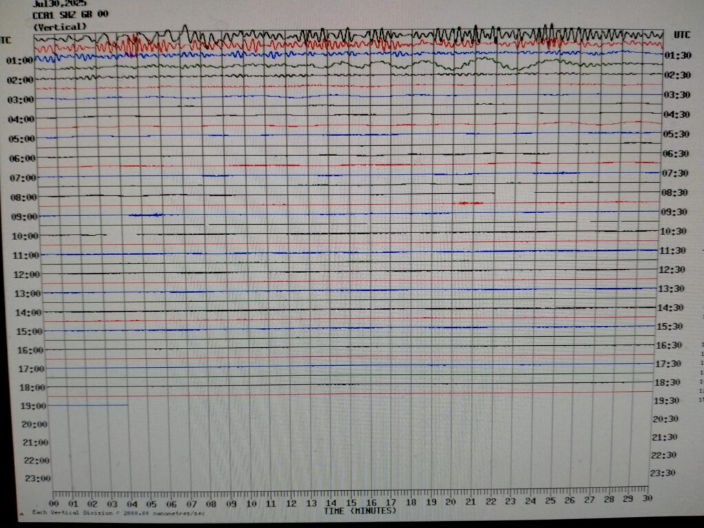
This is a screen shot of the Carnmenellis Seismogram (Cornwall, U.K.) which was recorded on the 30th July, 2025. Following the major earthquake which hit the Kamchatka Peninsula in Russia on 29th July, 2025 and that measured 8.8 on the Richter Scale, the seismic waves from this travelled all over the world. These were picked up and recorded at Carnmenellis as well and these can be seen above! (Please click on the link above to see the full size image!)